
Five-year Monitoring of Seismic Instrumentation in the Kealakaha Bridge
Dr. Ian Robertson obtained a five year (2015-2020) project from the Hawaii Department of Transportation (about $400,000) to instrument and monitor Kealakaha Bridge.

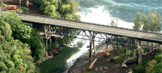
The seismic instrumentation of the Kealakaha Stream Bridge was initiated in June 2001. The project included the instrumentation of the bridge with a variety of electronic sensor systems primarily designed to monitor structural response during future earthquakes. The project also included development of computer models for analytical comparison with the measured response.
Because of delays in construction of the bridge, and major structural changes introduced during the value engineering process, a number of extensions were granted to complete the instrumentation project. In particular, the value engineering introduced base isolation to the bridge structure, the first such application in the State of Hawaii. The instrumentation systems were modified to accommodate the value engineering changes.
The duration of the project will ensure that the instrumentation is in working order during any earthquakes that occur before June 2020, thereby providing adequate data on the bridge performance to evaluate the original design, and help guide future designs of similar bridges with base isolation.
Advancing Best Practices for the Analysis of the Vulnerability of Military Installations in the Pacific Basin to Coastal Flooding under a Changing Climate
Dr. Ian Robertson is a participating researcher (about $40,000) in the NOAA funded (about $1.8M, from 2016 to 2019) project to determine the potential effects of sea level rise and storm surge on the infrastructure on selected military bases.

The objective of the overall NOAA project is to advance the practical application of statistical and other analytical techniques that can be used to assess the vulnerability of built and natural environments to the impacts of coastal flooding in a changing climate. The results will advance the practical applications of coastal flooding analysis, and will lead to an improved understanding of which components of DoD facilities and infrastructure are potentially vulnerable to coastal flooding and how they could be affected, as well as how species and ecosystems associated with DoD lands and waters will respond in a changing climate. They will be amenable to incorporation into site and region-specific tools and models to inform decision and policy making. The results will have broad interest within the region and the nation.
The UH CEE Department portion of the project involves site visits to various bases in the Pacific region, including Kwajalein, Republic of the Marshall Islands, Kaneohe Marine Corps Base, Oahu, Hawaii, and San Diego Naval Station, California, to determine the potential effects of sea level rise and storm surge on the infrastructure at these bases.
Natural Hazards Engineering Research Infrastructure: Network Coordination Office
Dr. Ian Robertson is a participating researcher (about $40,000) in the NSF funded (about $4.1M, from 2016 to 2020) project. He serves as senior personnel with primary contributions to the operation of the NCO including; expertise in tsunami engineering; participation in governance group operations; participation in the development of the NHERI Science Plan for 2016‐2020; active recruitment of under‐represented undergraduate students to participate in research opportunities offered through the NHERI REU program; and participation in planning for the annual NHERI‐wide Natural Hazards Engineering Research Summer Institute.

The Network Coordination Office (NCO) is responsible for coordinating research, outreach and educational activities at the ten NSF-funded sites forming the Natural Hazards Engineering Research Infrastructure (NHERI). The NCO is headquartered at Purdue University with Julio Ramirez as principal investigator
Structural Monitoring of Kolekole Bridge and Umauma Stream Bridge
Dr. David Ma secured a long term project (2013 to 2019 for the structural health monitoring of two bridges with support from the Hawaii State DOT and the Federal Highway Administration (about $700,000).
The monitoring system for the Kolekole bridge consists of sensors subsystem, transmission and acquisition subsystem and management subsystem. The sensor subsystem consists of a variety of sensors mounted on the bridge. The transmission and acquisition subsystem consists of several dataloggers that will be based on the final sensor count and the use of wireless sensors. Each of these dataloggers will be connected and controlled remotely through Internet connections. The management subsystem consists of a powerful database, processing programs and displays, from which data collected will be saved and processed to provide continuous update on the bridge performance.
The focus of the monitoring of the Umauma Bridge is on the strains of the UHPC joints and shear pockets. Embedded vibrating wire gauges will be installed during construction. The sensors will be installed in strategically selected locations forming a strain rosette at each location to determine the principal strains/stresses in the concrete. The layout of the sensors is included in the attached files. Data acquisition and transmission systems will be designed and deployed on the bridge. The data collected will be wirelessly transmitted to two substations located on the abutments and wirelessly transmitted to UH via cellular network.